my friend and me are physics students planning to do a weather ballon project. He has a lot of programming experience and worked briefly with Arduino and a RaspberryPi before, while I am new to this field, but do know Python and some basics of C/C++.
Our goal is to measure temperature, air humidity, position, pressure and perhaps some other parameters up to an altitude of about 30km. Of course we also want to take pictures and videos.
We were considering two options.
1.) Use an Arduino to collect the measurement data and a GoPro to take the pictures/videos.
2.) Use a RaspberryPi with a Sense HAT, external sensors and a camera module.
My friend claimed that it would be easier to program an Arduino, but wasn't sure what would be the better choice,
Do you think an Arduino is a good candidate for this job ? If so, what specific model could you recommend ?
I have wanted to do something similar to this for a long while but I have not gotten the chance to do so. Sparkfun has a good article about a very similar project found here. I would imagine the Arduino is more than capable of handling all that you are asking about. You might want to look into the weather shield and a microSD shield.
The electronic or programing side is not the main issue here, its the mechanicis of getting the balloon itself to 30,000M.
You really need to find someone local to you who is experienced in the subject and knows how to fill balloons safely, just right etc.
As an introduction you can experiment and do tests on the electronic and tracking side with foil party balloons. These are called pico balloons, around 36" diameter and when filled with just the right amount of hellium will rise to around 10,000M and float at that altitude for several hundread miles or more. Alternativly you add a little bit more hellium they will burst at altitude and you ge the fun of finding it again.
Pressure at 30 km is very low - too low for many pressure sensors. Keep that in mind when looking for a suitable sensor! Same for the temperature, it's pretty cold along the way, check what to expect and choose your sensor wisely.
And indeed find someone experienced in launching such balloons, and who also knows about where/when this is allowed. You don't want to risk hitting a passing plane, no matter how small this risk.
Recovering your kit may be one of the hardest parts of this project indeed, keep national borders in mind as well when planning your launch and where it may end up.
I have read about, but have no feel for LoRa, but it seems to be able to work for kliometers.
anyone know if it can be triangulated ? seems a LoRa sender could be used to pulse out a signal every so often and then allow you to triangulate it's postion ?
@smet
We hope to find somebody that sells such balloons. Otherwise we will need to construct ourselves (perhaps with some help of people that have launched balloons before), which could be diffcult.
We've planned to do a test flight with a drone (up to 650m), but maybe it's not a bad idea to investigate a test flight with a smaller ballon.
@ardly Track the position, check where it comes down and pick it up. At least that's the plan at the moment.
@wvmarle Thanks for the hints. We have these issues in mind. At the moment we are wondering what technicality to choose.
Check out the NASA's ASCEND program. Our student ascend club launches two balloons a semester. Here's a picture from my first balloon, taken with a gopro hero 4:
Fltr: @smet
We hope to find somebody that sells such balloons. Otherwise we will need to construct ourselves (perhaps with some help of people that have launched balloons before), which could be diffcult.
Buying the balloon is not difficult, but you need to know what type to get, how big, how to attach it all together and fill it.
I would not be expecting someone selling balloons to provide all the neccessary advice and guidance for free.
dave-in-nj:
I have read about, but have no feel for LoRa, but it seems to be able to work for kliometers.
anyone know if it can be triangulated ? seems a LoRa sender could be used to pulse out a signal every so often and then allow you to triangulate it's postion ?
Triangulation by signal strength comes up in here often, from ground to high altitude balloon is one situation where it might work since there is usually very good line of sight between ground the the transmitter.
However there is no real need to use traingulation at all, just put a GPS on the tracker and get the accurate location back in anycase.
LoRa balloon tracker can be very simple, see below. The full distance capability of LoRa trackers is yet to be discovered, the current recors stands at 702km from a balloon to a TTN\LoRaWAN node , 868Mhz, 25mW.
Check out the NASA's ASCEND program. Our student ascend club launches two balloons a semester. Here's a picture from my first balloon, taken with a gopro hero 4:
@ChrisTenone That is a fantastic photograph. What exactly are we seeing?
ardly: @ChrisTenone That is a fantastic photograph. What exactly are we seeing?
Thanks ardly!
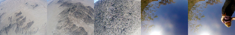
It's a go pro image taken at the moment of the balloon's burst. The flare in the top left of the picture is talcum powder, which is put in the balloon prior to filling (with hydrogen.) That way, when it bursts, it makes a small sparkly cloud that can be seen from the ground. The string with the boxes are the payloads - our balloons can carry about 17 pounds, so we have anywhere from 4 to 10 payloads. Each one has an experiment or two onboard. The bright part in the bottom right half of the picture is the Earth - Arizona to be exact - we launch from the University of Arizona farm in Maricopa, Arizona, because it is rural or raw desert for many miles in every direction. It appears curved because - duh - the planet is spherical, but the curvature is emphasized from the GoPro's barrel distortion. but it's almost flat - any line that passes through the center will be rendered rectilinearly. When I measure this picture, it's about 3% more curved than it actually is at this altitude (96,000 feet.)
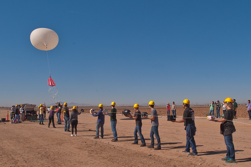
Here are a couple more pictures, the first one is the launch. Each payload team has a representative in the line (ours is the fourth from the right):
Next is a sequence of the recovery. The entire flight is between half an hour and an hour. We've tried a bunch of stuff, and the best seems to be a lora broadcasting gps data and an identifier code. That way we get a location, and drive, 4 wheel, and hike to retrieve it. It takes anywhere from an hour to a day and a half to recover the capsule. Over 8 launches, we have recovered all but one, although one recovery was little more than pieces of what used to be the student's semester long project. But this one was intact, and the gopro kept right on snapping:
Thank you all for your comments and especially ChrisTenone for these nice insights, the pictures are great!
We're finally leading towards taking a setup with a RaspberryPi, maybe adding a GoPro if we can afford it. The flight is planned for February/March, so there is still some time to go.
Fltr:
Thank you all for your comments and especially ChrisTenone for these nice insights, the pictures are great!
We're finally leading towards taking a setup with a RaspberryPi, maybe adding a GoPro if we can afford it. The flight is planned for February/March, so there is still some time to go.
How did this one go, did you launch, did you get any photos?